


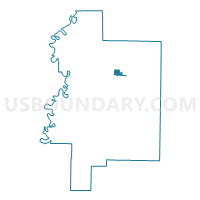
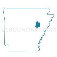
McCrory Precinct 17, Woodruff County, Arkansas
About
Outline

Summary
| Unique Area Identifier | 528552 |
| Name | McCrory Precinct 17 |
| County | Woodruff County |
| State | Arkansas |
| Area (square miles) | 1.28 |
| Land Area (square miles) | 1.28 |
| Water Area (square miles) | 0.00 |
| % of Land Area | 100.00 |
| % of Water Area | 0.00 |
| Latitude of the Internal Point | 35.26181890 |
| Longtitude of the Internal Point | -91.19680440 |
Maps

Graphs
Select a template below for downloading or customizing gragh for McCrory Precinct 17, Woodruff County, Arkansas


Neighbors
Neighoring Voting District (by Name) Neighboring Voting District on the Map
- Fakes Chapel Precinct 20, Woodruff County, AR
- McCrory Precinct 18, Woodruff County, AR
- McCrory Rural Precinct 15, Woodruff County, AR
- Pumpkin Bend Precinct 19, Woodruff County, AR